Well let's lace our hiking boots back up and continue our journey across South Manitou island. I left off last time as I made my way through the virgin grove of Northern White Cedars (Thuja occidentalis) known as the Valley of the Giants on the southwest corner of the island. The first post was spent almost entirely in the fertile, moist hardwood forest that graces most of the islands surface but be prepared to enter a completely different world on this second stage of the journey. This time we are starting on the western edge where the trees stop and all you can see is the beige colored sand of the perched dunes of South Manitou Island.
When hiking through the Valley of the Giants you will notice as you get to the rear of the grove that it is backed up against a huge, tall wall of sand that climbs steeply to a height over the canopy of the forest. This is the trailing end of the perched dunes that run along the west side of South Manitou. Getting to the top will get the blood flowing and make your calves feel as if they were on fire but trust me when I say it's all worth it in the end. Many biologists and geologists agree that these dunes are one of the best examples of this type to be found in the country and should be preserved at all costs. Perched dunes are rare globally because they only exist under the right geomorphilogical conditions. Thousands of years ago glaciers carved out the enormous basins of the world-famous Great Lakes. As the glaciers moved they sliced out a ridge of limestone along the area that is now the north-eastern section of Lake Michigan. As the climate warmed and the glaciers slowly shrank back and receded to the north, the huge basins filled with melt water and the tops of these ridges were exposed as a chain of islands that exist to this day. South Manitou starts off the chain of islands which extend northeasterly across Lake Michigan and include the islands of North Manitou, the Fox Islands, Beaver Island, all the way to the famous Island of Mackinac. Over the course of thousands of years the westerly winds have carried sand up onto the steep cliffs and bluffs of South Manitou, depositing their loads and creating the perched dunes you see today. North Manitou and some of the other islands show good examples of this type of dune environment but none can touch the quality, size and naturalness of South Manitou's.
 |
| Sweeping dunes atop the western edge of South Manitou Island |
The above picture shows the drastic change in environment as you move upward across the eastern edge of the perched dunes and come up out of the "lush" hardwood forest from below. Not only does the scenery change abruptly but so does the vegetation type and plant species. The switch from plants that appreciate the rich, moist soils of the northern forest to species that are more accustomed to living and surviving in harsh, desert-like conditions is like stepping from a dark room into daylight. Dune vegetation, most specifically the grasses, play a vitally important roll in keeping the health of the dune ecosystem at a max. A few of the most common grasses found on the dunes are Prairie sandreed (Calamovilfa longifolia), American beachgrass (Ammophila breviligulata) and Prairie Junegrass (Koeleria macrantha), the last two being state-listed in Ohio. Without the root systems of these plants the wind and rain would quickly diminish the quality and structure of these rare and ecologically important areas. The picture from above shows off some of the more common species of plants found on the dunes. The large, shrubby bush in the center is Buffaloberry (Shepherida canadensis) while the darker green shrubs in the background are Common Juniper (Juniperus communis). The green, prickly plant seen covering most of the sand is another Juniperus species, the Creeping Juniper (Juniperus horizontalis). If you click the photo to see a larger version you will notice small pockets of a yellow flowering plant; this is Hoary Puccoon (Lithospermum caroliniense) which is a threatened species in Ohio only being found in select areas on the dunes of Lake Erie. Even more challenging to see just behind the Buffaloberry are the orange blooms of another threatened Ohio species, Wood Lily (Lilium philadelphium). Like I mentioned before, this island and area of Michigan is full of species found commonly up here but very local and rare in our state.
 |
| Looking back across the island at the bay |
As you get higher towards the 'top' of the island you start to realize the amazing 360 degree panoramic view you have of the mainland and surrounding Lake Michigan. You can now get a good look at where you've been, where you are going and just an overall grip on the size of the island and it's noticeable landmarks. Above is a shot looking northeast across the island. Just barely seen jutting out into the water is the northern arm of South Manitou that helps create the natural bay discussed in the first post. This is hardly the only important service it provides to the island. The tip of this peninsula is called 'Gull Point' and is a critical breeding area for the highly endangered Piping Plover. According to the Michigan DNR there are as few as 30 mating pairs in the Great Lakes and a few are known to use South Manitou as a vital nesting ground. North Manitou (the landmass in the background of the above photograph) also has known nesting grounds for the Federally threatened Piping Plover.
 |
| The federally threatened Pitcher's Thistle (Cirsium pitcheri) |
Speaking of Federally threatened species, this is the likewise Pitcher's Thistle (Cirsium pitcheri). Only found in four Great Lake states growing directly on the dunes along the shore, this plant is quickly losing its already limited habitat. For those who are my faithful and devoted readers (and I sincerely thank you for those that are) you will remember I did a separate post about this plant here. If you are interested in learning more about this plant I highly suggest taking a look at that post if you haven't already. Another rare and state threatened species frequently found on the dunes is Clustered Broom-rape (Orobanche fasciculata). It is parasitic to the roots of other plants in the Asteraceae family but only found growing on Wormwood (Artemesia caudata) on South Manitou.
 |
| Looking back at the mainland and the Sleeping Bear Dunes |
Looking back southeast across the canopy of the forests to the mainland you can see the Sleeping Bear Dunes on the right. Larger (in height and area) than the dunes of South Manitou they were formed in the same manner as described earlier. These dunes are not nearly as pure and unspoiled as South Manitou's due to heavy foot traffic by tourists and hikers. Right on the shore, near popular summer vacation spots, these dunes see thousands of visitors a year that put millions of footprints in the sand deteriorating the structure and vegetation with each step. While South Manitou get's its fair share of visitors each summer, the very large majority are day hikers and do not spend more than the allotted 5 hours on the island before the ferry leaves. The hike to the Valley of the Giants alone is a six mile round trip so very few people have time to see the dunes and even less time to explore them. That has been the fortunate secret to keeping South Manitou's as high quality and pristine as possible.
 |
| Harebell (Campanula rotundifolia) growing on the dunes |
These beautiful and delicate purplish-blue flowers are found all over the dunes, especially as you get higher towards the apex at the edges of the bluffs. This plant is known as Harebell (Campanula rotundifolia) and while found all over Michigan it is very rare in Ohio. Oddly enough one of the only known populations in Ohio is in my home county of Miami, growing on the cliff sides along the Greenville Falls near Covington.
 |
| The western dune bluffs of South Manitou Island |
This is one of my favorite views from one of the highest points on the island. Looking directly west across the crystal waters of Lake Michigan you can almost see the curvature of the Earth on the horizon. While spending so much time in the darkened and shaded forest it feels like you are on a different world on top of the island. An arid desert is stretched out before you with nothing but sand, wind and skeletons of ancient cedars long lost to the ever moving sand dunes. Don't let the distance fool you, it's a healthy mile to the edge of the island from the vantage point in this photograph.
 |
| Ancient, bleached skeletons of White Cedar trees long forgotten |
Scattered throughout the perched dunes are sun-bleached skeleton cedar trees that have been weathered and sand blasted to a natural smoothness that feels unique to the touch. Perched dunes are by no means a static environment. The winds are ever shifting their positions, extending and diminishing their ranges. Hundreds of years ago as the dunes shifted, these live and thriving cedars were swallowed by the oncoming dunes only to be excavated by the winds centuries later to stand as relics of their once great empire.
 |
| White Wand-lily |
 |
| Dead cedars clinging to the bluffs |
A former stand of White Cedars clinging to the cliff face of the dunes makes for an impressive sight. The ever shifting positions of the dunes can expose old soil layers which can give researchers an inside look at the history of the previous vegetation. One of the most interesting plants, least in my opinion, on the island was the large presence of White Wand-lily (Zigadenus glaucus), which is pictured above. Also known as White Camas or Death Camas, this plant was found growing all over the dry, sandy dunes along the high bluffs of the island. This is considered a potentially threatened species in Ohio and is found growing most commonly in fens, which is the only place I've ever seen it in our state. On South Manitou it was growing in a completely different type of environment all together, not to mention in greater and healthier numbers. Interesting how this plant can be found in such varying habitats in different areas of the country.
 |
| What a view! |
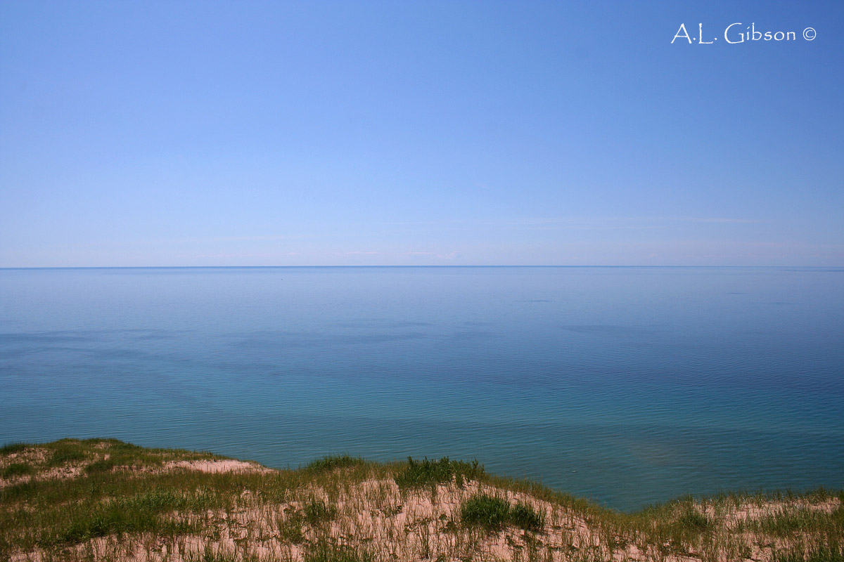
On a day with perfect climatic conditions it is possible to see the eastern shores of Wisconsin, nearly 50 miles away from the top of the island. While it was a clear and sunny day when I found myself peering westward the atmosphere was too humid and the air had a hazy mist to it on the horizon, preventing me from seeing all the way across the Great Lake.
 |
| Western edge of the island |
 |
| Sand dune bluffs |
Standing at the very edge of the bluffs looking to the north and south shows just how high up and steep the perched dunes are. About 400 feet above Lake Michigan and slopes approaching 30 degrees, these gigantic piles of sand are nothing to mess around with. Getting down is one thing, but getting back up is a lot more of a challenge than these pictures portray. You can see how the winds coming in from the west would hit these walls of sand and limestone and push the loose sand up and over the ridge and slowly fill in the island. While the east side of the island is a deep watered and sheltered bay, the west side is open to all attacks by the elements. Looking from the shore out into the lake you can see how shallow the water is further out in the lake as the sand gets blown in closer and closer to the perched dunes.
 |
| Northern shore of the island facing N. Manitou Island |
At the northern end of the island I decided to climb down to the lakeshore and follow its edge until I picked up a trail heading down the center of the island that would eventually get me to my campsite for the night, which was all the way down on the southern end at the Weather Station Campground. Much like the eastern shoreline of the island, the north is gently sloped right down to the water with the coastal forest starting about 25 yards inland. The land you see on the horizon is the upper half of North Manitou. You can see the perched dunes of the neighboring island rising up from the lake.
 |
| An American Toad nestled amongst the sand and shells on the beach |
While sitting on the shore soaking my tired feet in the chilly waters I noticed this little guy nestled amongst the sand and shells on the beach. American Toads (Bufo americanus) are a common occurrence on the island and provide many a meal for the equally numerous Garter Snakes that abound. Unfortunately on my walk through the interior of the island down to my campground provided little opportunities for photographs. Honestly, it was most likely my exhausted feet and sore back from carrying my 40+ pound backpack with all my camping gear over 10 miles across some hilly ground and the fact I ran out of water halfway across the perched dunes. Not a very fun area to run out of water! Once I reached the campground at Weather Station I set my tent up in-between two ancient Beech trees and cooked myself dinner with a beautiful view across the lake back at the mainland. A refreshing swim followed with a relaxing layout on the beach hit the spot as I watched the sailboats glide through the waters. I looked back at the mainland and wondered what delicious restaurant my parents decided to eat at. I assume it was better than what I mustered up earlier but I can safely say they couldn't beat my view.
 |
| South Manitou lighthouse |
 |
| Lighthouse |
I awoke early the next morning to the sound of American Redstarts just warbling away in the Beech trees above me. Wish I could wake up to that kind of alarm clock more often. I decided to keep to the shore and make my way back to the lighthouse and dock to check in when the ferry arrived. The 100 foot tall lighthouse was built in 1871. Its powerful light had a range of 17 miles and guided countless ships safely through the Manitou Passage until its retirement by the Coast Guard in 1958.
 |
| The deep and sheltered bay of South Manitou |
After arriving back at the dock I decided to relax for the afternoon while the day crowd explored the island. I took a leisurely walk along the shoreline of the bay and after finding myself quite alone, stripped down to my skivvies and took a long dip in the bay. Few things are as purely refreshing and cleansing as swimming in Lake Michigan. Even during the hot summers the water temperature never makes it out of the 60's, making for quite the chilled swim even in the middle of July. A few hours later I was once again on the ferry making my way back to Leland and to civilization. I will leave you with a photograph of one of northern Michigan's famous sunsets with South Manitou Island on the horizon, soaking in the waning oranges and reds of the setting sun. Thanks for reading and I hope you enjoyed my journey across one of Michigan's greatest natural treasures! I cannot wait to go back!
 |
| Perfect northern Michigan sunset |


Andrew, awesome post! I remember seeing harebells along the alvars at Middle Bass Island when I worked up there. Pretty soon, redstarts will be chirping away here as well. I enjoyed this series. Hopefully I'll have the chance to visit one day!
ReplyDeleteThanks, Mike! I would definitely take the time to see this place if ever in the area of given the chance. I know everyone's lists of places to visit, mine included, are a mile long and grow everyday but this certainly deserves your time.
ReplyDeleteI have made the trek to the Valley of the Giants. All botanists should! I remember clawing my way through a white cedar forest to wet marsh along a stream flowing out of the cedars, a magical spot. Blooming in the marsh was Grass of Parnassus, a first for me at the time. Beautiful plant. Can't remember which species it was? Did you see this plant there? If not, guess you better plan another trip. Chris Bedel
ReplyDelete